Friday, June 22, 2012

Valle Canyon Trail Ready for Boots and Bikes

Valle Canyon has long been one of my favorite local haunts. It has history (the road up the canyon has been used for at least 150 years), some running water, an impressive summer collection of wildflowers, and monster conifers to shade parts of the path. Running from New Mexico Highway 501 to the boundary of the Valles Caldera National Preserve, the trail/road also provides a modest challenge by gaining 1200 feet over 3.2 miles. On foot and on bike, I've traveled the length of the canyon maybe 50 times over the past 25 years.

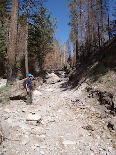
The trip was severely altered on June 28, 2000. About 1.5 inches of rain fell on the upper watershed that 6 weeks before had been intensely burned by the Cerro Grande fire. In less that an hour, a section of trail was transformed into a 6-foot deep trench.

In July 2000, June Fabryka-Martin and Eric Peterson survey the damage brought by the June 2000 storm in the Valle Canyon Watershed

 But wait. It got worse.
Approximately the same spot of the 2000 photo above in May 2011, post-Las Conchas Fire
After a storm dumped more than 2 inches of rain in less than an hour on the watershed in August 2011, many sections of the old road were radically altered.

The old road covered by snowy rocks in November 2011. The trail followed the old road here.
To speed up the rehabilitation process, the Forest Service brought in a mini-bulldozer in April 2012. The first quarter mile of the old road was spared the dozer blade, leaving a rocky stretch, but the next half mile of the old road was restored with the dozer blade.

A mini-dozer called a Sweco graded the lower stretch of the Valle Canyon Trail in April 2011
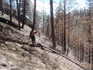
Near the location of the erosion channel from 2000 pictured above, the dozer was stopped by steep terrain. It was time for old-fashioned trailbuilding with hand tools and the sweat of the young. The Forest Service Recreation staff--Lynn Bjorkland, Jennifer Sublette, and Miles Standish--joined me in the difficult task of laying out a bypass route around the doubly-entrenched erosion channel.We knew that in June, the Los Alamos Family YMCA Youth Conservation Corps (YCC) crew, a highly motivated group of young adults who had cut their teeth building trails for me on County Open Space, would be trained on trail building in burned area on this difficult stretch.


Lynn Bjorklund gracefully balances on a steep sideslope while laying out the Valle Canyon bypass route in May 2012.
Trail layout is a lot like sequencing words in a book. There's a rough draft followed by endless edits.When the YCC crew arrived, the crew leaders had their own version of the story, and the final route was a combination of the ideas of all the authors. We collectively settled on a trail that climbs the north side of the canyon wall for about 100 feet, stays above the erosion ditch and the cliffs that border it, then in 0.3 miles descends to the original road to continue up the canyon. The bypass of the erosion channel crosses a 45-degree slope. The beauty of working with such a skilled, dedicated trail crew is when all is decided, the leader says, "Build it," and through hours of hard work, it happens. 


The YMCA YCC crew was composed of 8 members from Los Alamos and 8 members from outside Los Alamos.  Over the past 4 years they have completed projects such as the Tent Rocks Trail, the Fireline Trail, and the Zipline Trail.
The bypass route was a difficult task, but the crew rose to the challenge and created a legacy project. The trail has two switchbacks to maintain an overall 5% grade as it ascends and descends the slope above the post-fire erosion channel.
The lower switchback on the bypass route

The trail corridor traverses a steep slope. The grades are reasonable, but there are several trees close to the trail that will be a problem for mountain bike riders.

Above the YCC crew's bypass route, the trail returns to its former route along the old road. Sections are washed out, overgrown, or rocky as they pass through the post-fire flood zone. But the entire route is open and easy to follow to the Valles Caldera fence. The uppermost half mile of trail is still intact.

Makeshift crossings, debris flow drainage cuts, and narrow trail treads mark the upper  1.5 miles of the Valle Canyon Trail.

Overall, the Valle Canyon Trail is back. It's still a great trip, moderate on foot and challenging on a bike. I counted 54 species of wildflowers in bloom this week, so it's a great season for exploring the canyon.


UPDATE, November 2012: After three intense summer/fall storms, the trail is holding up very well. Users are wearing in the tread and the trip up the canyon is less rough than it was right after it was rebuilt. In late October, a group of mountain bike riders improved the upper switchback by moving heavy rocks and increasing the turn radius. It's pretty sweet now.


Cañon de Valle Trail at EveryTrail

EveryTrail - Find the best Hiking in New Mexico

No comments:

Post a Comment

Please enter reports on trail conditions. Thank you.